|
Port Information
Latitude / Longitude: 43.973° / 09.418°
Local Time: [UTC +3.5]
Un/locode: IR
|


| SAROOJ JETTIES |
|
||
| Country: Iran (IR) | updated 2018 |
SAROOJ JETTIES
Anchoring Geographical Position is 35, 47 N & 51, 3 E
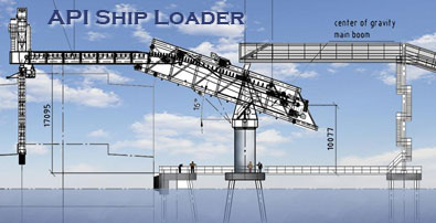
Sarooj harbour complex plan calls for port facilities, prolonged jetty, office buildings, ship yards, warehouses, open stores, and hostel accommodations. The API jetty is designed for bulk export and is equipped with ship loader to expedite loading operation. This jetty is located at the shore of the Persian Gulf deepest water, at equidistance from Dubai and Kuwait or from Bandar Abbass and port Imam Khomeini. Sarooj Jetty final stage enjoys 18 meters berth depth to receive PANAMAX class of bulk carriers.
Sarooj Jetty/Kangan is under Assaluyeh port authorities jurisdiction at present.
Capacity of Berth
1st Berth 50000 mts
2nd Berth 5000 mts ( 15000 mts dwt barges berth at this Berth), loading with Ramp and
Dump truck
– Max. Ship Loader Loading rate 1500 mts per hour
– Acutal loading rate working 24hrs = 8000-10000 mts per day
– Max Draft 18 mtr
– Type of Berth Dolphin
– Length of Berth 220 mtr
– Max. Vsl. DWT 50000 mtr