|
Port Information
Latitude / Longitude: 30.448875° / 49.076245°
Local Time: [UTC +3.5]
Un/locode: IRBIK
|
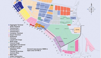
BERTHS SPECIFICATION
|
Jetty No. |
|
Length |
Draft |
|
|
No. |
Application |
Meter |
Meter |
Remark |
|
1(NOT READY) |
Bulk |
165.00 |
14.00 |
Fixing evacuators in process |
|
2(NOT READY) |
Bulk |
165.00 |
14.00 |
Fixing evacuators in process |
|
3(NOT READY |
Bulk |
165.00 |
14.00 |
Fixing evacuators in process |
|
4 |
OIL |
175.00 |
13.00 |
|
|
5 |
OIL |
175.00 |
13.00 |
|
|
6 |
Steel and Bulk |
182.00 |
13.00 |
Aluminum Co. Private Jetty |
|
7(BASIN) |
General |
182.00 |
||
|
8 |
General |
182.00 |
11.00 |
|
|
9 |
General |
182.00 |
11.00 |
|
|
10 |
General |
182.00 |
11.00 |
|
|
11 |
Container |
210.00 |
12.00 |
|
|
12 |
Container |
210.00 |
13.00 |
|
|
13 |
Container |
210.00 |
13.00 |
|
|
14 |
Container |
210.00 |
13.00 |
|
|
15 |
General / Bulk |
210.00 |
12.00 |
|
|
16 |
General / Bulk |
182.50 |
13.00 |
|
|
17 |
General / Bulk |
182.50 |
12.00 |
|
|
18 |
General / Bulk |
182.50 |
13.00 |
|
|
19 |
General / Bulk |
182.50 |
12.50 |
|
|
20 |
General / Bulk |
182.50 |
12.50 |
|
|
21 |
Bulk & Liquid/tanker |
182.50 |
12.00 |
Private Jetty |
|
22 |
Liquid/ Tanker |
182.50 |
12.00 |
Private Jetty |
|
23 |
General- Bag cargo |
182.50 |
12.00 |
|
|
24 |
General /Bulk |
182.50 |
12.00 |
|
|
25 |
General/Bulk |
182.50 |
12.50 |
|
|
26 |
Bulk |
182.50 |
12.50 |
|
|
27 |
Bulk and General |
182.50 |
12.50 |
|
|
28 |
General /Bulk |
182.50 |
12.00 |
|
|
29 |
General/Bulk |
182.50 |
12.00 |
|
|
30 |
General/Bulk |
182.50 |
11.00 |
FOR EXPORT |
|
31 |
Bulk |
182.50 |
12.00 |
FOR EXPORT |
|
32 |
Bulk |
182.50 |
12.50 |
FOR EXPORT |
|
33 |
Bulk |
182.50 |
12.50 |
FOR EXPORT |
|
34 |
Oil |
182.50 |
12.50 |
FOR EXPORT |
|
37 |
Oil/Bulk |
240.00 |
9.00 |
FOR EXPORT |
|
38 |
Oil |
200.00 |
9.00 |
FOR EXPORT |
|
Silo Jetty |
Grain |
240.00 |
10.00 |
GRAIN |
APPROACHES: Shipping channels well marked with light beacons and buoys and present
no navigational difficulties in clear weather (30 numbers of beacons, 40 numbers of buoys
and 2 light vessels). Small unlit tide gauge platform located on edge of the shoal west of
shipping channel in Lat. 29˚42’30″N., Long .49˚03’48″E., approximately 1.75 miles west of
Khor Musa Approaches Buoy No.4, and shown on Admiralty Chart. Approaching vessels
should steer for Khor Musa Light Float, in position Lat. 29˚36’32″N. , Long.49˚ 34’47″E., and
from there a course should be set along marked channel for Buoy No. 12 in position Lat
.29˚53’20″N., Long. 49˚12’32″E., and Buoy No.7 in position Lat. 29˚53’37″N., Long.49˚12’E.
Length of the channel: 69 miles.
Minimum Width : 200 meter from beacons 9-14 to beacon 30-23.
Minimum Depth 13 meters . (last date of dredging December 2010)
Maximum tide in Khowrmusa 4 meters and in Bandar Imam Khomeini 6 meters .
Strategic port facilities
|
Type of equipment |
Capacity (ton) |
Number (unit) |
|
Liebherr crane |
140 |
8 |
|
Liebherr crane |
25 |
4 |
|
Liebherr crane |
100 |
1 |
|
Liebherr crane |
50 |
1 |
|
Heavy duty crane |
550 |
1 |
Grain Terminal Equipment for Loading & Unloading
|
Kind of Equipment |
Capacity (Ton per Hour) |
Number (unit) |
Max. Capacity (Ton per Hour) |
|
Pneumatic Ship Unloader |
250 |
7 |
1750 |
|
Pneumatic Ship Unloader |
300 |
2 |
600 |
|
Pneumatic Ship Unloader |
600 |
2 |
1200 |
|
Chain Ship Unloader |
400 |
2 |
800 |
|
Bowl Ship Unloader |
600 |
2 |
1200 |
|
Total |
5550 Tons per Hour |
||
Container Terminal Equipment for Loading & Unloading
|
Type of Equipment |
Capacity (Ton) |
Number (Unit) |
|
Gantry Crane |
40 |
4 |
|
Transtainer |
40 |
5 |
|
Reach Stacker |
45 |
3 |
|
Gottwald Shore Crain |
100 |
3 |


